Showing posts with label Pedder Wilderness Lodge. Show all posts

Saturday, 4 March 2023

MOT Tour Day 38 - Strathgordon

Ted's Beach
Third day at Strathgordon and we spent it cleaning up the bits we hadn’t done. Starting after breakfast, we walked a hundred metres to Jack’s track, a short 30 minute walk reputed to be a lovely example of rainforest.

Nope. Overgrown, wet and not recently walked, we were brushing vegetation aside to try and make passage. Given warnings about the number of Tiger Snakes about, the latest - issued as recently as yesterday by reception staff - we bailed. The decision had no sooner been made than I came a cropper. A thin layer of wet soil over a flat section of wet rock caused slipping of my boot and I folded up like a cheap picnic table from ALDIs.

No great damage done. Knee is a bit sore. Ego will heal.

We retraced our original path coming to Strathgordon. It looked better without the rain. A few stops along the way enhanced our knowledge of the place - its history and geography.

Ted’s Beach is the main camping area, located right on lake’s edge, with supplied septic toilets, camp kitchen and limited access to power through a few power points in the camp kitchen. No power, no water so you need to be self-sufficient.

McPartlan Pass Canal
At McPartlan Pass Canal, we found out that Mr McPartlan was an intrepid explorer, the first white man to find a passage west as far as the place that would become Strathgordon. The canal we were looking at connects Lake Pedder to Lake Gordon, so that water can be channelled through to Lake Gordon power station to generate electricity. About 41% of the power produced at LGPS comes from Pedder but it needn’t be so. It was at this point in McPartlan’s journey west that he found a pass through the mountains and down into the original Lake Pedder. The engineers, a hundred years later, took advantage of the easy passage to push through a canal.

Our last point before return was at an art installation called Bitumen Bones. Art installation, I hear you cry! Yes, at the most dramatic bend in the Gordon River Road, one where the Sentinel Range is close enough to intimidate you, Alex Miles has created an immersive sculpture depicting bleached skeletal remains of a wombat which has become road kill, which is being picked over by a crow. On one wall, the poem by Sarah Day which inspired the piece, has been reproduced. How wonderful to see a poet’s words so publicly recognised.

Bitumen Bones & the Sentinels
Of course, the main event are the Sentinels, a range which run like the spine of a giant laying face down beside Wedge River which flows past in the sharp valley below where you stand. The pink quartzite is exposed in monumental cliffs above you and vegetation fills cracks and crevices in defiance of gravity or common sense. It’s an awesome scene so reminiscent of the Scottish Highlands that difference is hard to tell.

The scoot back to Strathgordon was fun. With no van on the back to be responsible for and in dry weather and over a slightly more familiar track, I could “drive” the road closer to my and the Forester’s capability.

In the afternoon we readied the van for travel tomorrow, powering up its systems and returning clothes and other items to its cubby holes, before a few beers on the deck of the Wilderness Lodge with the Pedder and her mountains as companions.

Click here for today's photos
Strathgordon - Pedder Wilderness Lodge - has been a wonderful break from close-quarters living, coming as it has halfway through our Tassie odyssey. Another awaits us up in the mountains at Lake St Clair, starting from tomorrow.

Friday, 3 March 2023

MOT Tour Day 37 - Dams & Lake Pedder

In a place where an average 253 days of the year are overcast or raining, today’s clear blue skies were part revelation, part pure blind luck. 

My day started a little earlier than Sue's.

Lake Pedder at sunrise

I was up with sunrise and scantily clad owing to haste at getting down to Lake Pedder: if you can call a tracksuit scanty! The reward came with the views. Catching the lake still in its state of nighttime quiet and the sky in transition, even on the iPhone I was able to trap some of the mood. The mountains off to the south were taking potluck with the sun: some reflecting early rays, some still in their night shadow pyjamas. The lake was fairly still and dark and the mountains which photo-frame its existence to the east, danced a morning of silhouette and golden outline. The sun was up but hidden by their bulk.

One picture became another, each better than the preceding.

When I returned home, Sue was given a crumpet with a cup of tea to encourage her from bed and I finished yesterday's task by completing the folding of washed clothes.

From then until a late lunch, we wandered the two dams to our west, the Gordon River Dam and the Serpentine.

Lake Gordon is larger than Lake Pedder and exists to its north. Between them, they are the biggest pondage of water held in Australia, their 514 square kilometres being 31 times Sydney Harbour (goodness knows how many MCG's or Olympic swimming pools!) still above the dam but within walking distance.

Gordon River Dam
After visiting the vertigo-inducing lookout high above the Gordon River Dam and snapping the icon shot of the great double curved wall, we drove down to a point still above but closer to the wall. From there to the top of the wall requires negotiating 185 steps on the steep metal staircase constructed for workers. Its quite a negotiation. We found the trick was to keep looking at your feet. It not only prevented the swimming head associated with vertigo but it was a safety thing: it is your feet that are going to foul you and send you toppling.

Once on the wall, the whole experience becomes a matter of being staggered by scale. Standing in the middle of the obvious horizon curve, you also become aware of the vertical curve of the concrete wall. This double curve is the reason the great body of water behind you doesn't push on through. I couldn't help thinking about the opportunity offered by a Hobart company to step backwards off the wall at that point and abseil down the vacant curved face of the wall, 140 metres to the bottom. I love abseiling but I'm not sure I could take on the biggest commercial abseil in the world.

Then there are the caged ladders that descend in sections down the face. Who the hell uses them? Or the tracked and enclosed elevator platform that lowers down from above the wall, to the very bottom, to allow equipment and men to service the dam. Two cables bear the weight and responsibility for their safe passage.

Beyond the wall, the Gordon River flows benignly on. On the forward face, a great mass of black water gathers itself. Around the lake for near and far, deadly faces drop into the water with murderous intent and off in the distance, the tops of long dead trees are all that are left of greenery that once were giants but now are just navigation hazards. The water level looked to be half capacity.

As much as I admired the engineering and the science behind it, the deathly price to parts of the environment was a little too obvious.

From here, we stopped off at the power plant which uses this stored pondage to contribute to the 13% of Tasmania's electrical power created by hydro-electricity. There's not much to see as most of it is below the surface. A tower offshore and some heavy duty power lines are all that there is to see. One of Tassie Hydro's well placed information boards explained it all to us.

At Serpentine Dam, we found one of the three the culprits which caused the pondage that is Lake Pedder. The original Pedder was a delightful lake at the bottom of a glacial valley, where terminal moraine had caused the Serpentine and Huon Rivers to be dammed. Its 10 square kilometres had a pronounced pink sandy quartzite beach. It was untouched by humans and pure in its delivery of a unique environment for plants and animals.
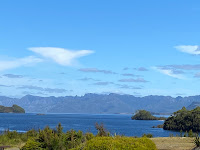
Lake Pedder
Then science stepped in ... oh and engineers ... and especially politicians. Premier Reece of Tasmania decreed that Tasmania needed power and Hydro would provide it. Pedder 1 was damned at Serpentine River, Scotts and Edgar Dams and the new Pedder 2 was born. Now it covered 242 square kilometres and thanks to a canal built to join it with Lake Gordan, it would also feed the Gordon Power Station. The problem is, it was unnecessary because at peak load, only 1.8 metres depth of Pedder's now 20 metres is needed. Other solutions could have provided better results.

There still remains a push to drain Pedder 2 but the estimated cost will be up to $100 million to do the works and revegetate the area. It will never happen. Good cause, wrong decision.

Sue stamped on the wall of the Serpentine Dam in the only protest she felt open to her.

In the late afternoon, we went for a walk through what had been Strathgordon and now is Pedder Wilderness Lodge (our hosts). Strathgordon didn't exist before 1972. It was a prefab village created for workers building the dams and at its peak, 2,000 of them lived here with most conveniences (supermarket, entertainment etc). The buildings we are domiciled in were built later for those maintaining the dams but no longer needed because of automation. The prefabs are long gone, moved to other dam projects in Tasmania. At the last census, Strathgordon had a population of 15 permanent residents.

Click here for today's photos
We finished at the bar of the Wilderness Lodge, sitting on the deck with a few beers in the late afternoon sunshine. Our backdrop was Lake Pedder and the mountains near and far. Not bad.

Every day in Tasmania just seems able to up the wow ante.


Thursday, 2 March 2023

MAP OF TASSIE TOUR Day 36 - Freycinet to Strathgordon

A long day. 

Today was always going to be the longest driving day of the Tour but it was exaggerated by several things which made the 360kms traveled much harder.

Firstly, I programmed the GPS incorrectly before I left. It gave me two alternative routes and I chose the wrong one. I didn't realise we were headed inland and over the coastal mountains to Campbell Town until it was too late to change. Poor Sue was hopelessly lost use her paper maps to check our progress, constantly looking for indicators along the path she thought we were taking and not finding them. Right couple of duffers we were but I take the majority blame.

Anyway, not to worry. We got an early taste of Campbell Town, grabbed some petrol and headed south down the main north-south highway of Tasmania and enjoyed trailing at 100km/hr ... 40 one minute, 60 the next! Roadworks like you wouldn't believe went on and on for tens of kilometres. Not just a stop/slow and on you go to the next one down the road a bit. No, no. This was kilometre after kilometre driving at 40 and adding more woe to my GPS stuff up.

We finally reached New Norfolk after crossing the Derwent River at Bridgewater and beginning our generally western direction toward Strathgordon. The river was filthy with Black Swans, something Tasmanians like to claim over Western Australians, according to our Tamar River skipper, back in Launceston. 

We stocked up on groceries (as usual, the Woolies staff were most accommodating) red wine and a few other things and took to the road. There was great variation in the quality of the surface and the width of the carriageway but the bends were consistent. At Westerway, we topped up the fuel tank to make sure we would have enough for the next few days. The lady at the petrol station/post office/general store/cafe not only had several hats but she also wore a cheery disposition. 

After Westerway, the bends became more extreme and the rain graduated from mist to drizzle to calling off cricket. Our only view was a wall of forest which we couldn't see for all the trees. We spent sixty long kilometres over the next hour with no change to that perspective when suddenly, the trees were gone on the one bend and huge mountains - right on the roadside - replaced them. It was almost frightening. It was very reminiscent of the landscape around Glencoe in the highlands of Scotland. We stopped for photos but were mindful to keep an eye out for Campbells.

Lake Pedder arrived soon after, although the rain made a gasping reaction, limited. Maps I had studied at home in the years of preparation suddenly had a three dimensional substance to them.

Arriving at the Pedder Wilderness Lodge - one of two cabin breaks we will have at the midpoint of our Tour, we gathered instructions from Reception and tried very hard to comply but the place they wanted me to park the van while we are here was untenable. A steep, bitumen road is not a good place for a lonely caravan. Instead and with the happy agreement of our new neighbours, we squeezed into the shared parking space outside our unit.

Click here to see today's photos
As I write, huge mountains tower above us and Lake Pedder is so close, even son Chris could throw a cricket ball into it from our front door.

A dull day but life's experiences can't all be Hazards!

462 km @ 10.49 (3,277 km @ 11.87 L/100km)